June of 2016
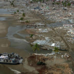
In June of 2016, the Province of BC conducted the largest multi-agency emergency response exercise in its history. The exercise was designed to test elements of a newly revised Provincial response plan to catastrophic earthquake in the Lower Mainland and Vancouver Island areas. The exercise spanned all levels of government from local to federal, involved dozens of agencies, and provided the opportunity to test some business practices around a common operating picture (COP) for emergency management.
A data aggregation software tool was used to demonstrate some elements of a COP. This tool allowed for remote field data collection in a device-agnostic environment and the generation of near real-time data into a common spatial display. This spatial display tool had reporting capabilities so query based lists and summary reports were readily available. Four key activities were conducted. The data generated by these four activities was received into the spatial display in near real time or real time, depending on the connectivity of devices.
The first activity was a scripted simulation of aerial damage assessments of all major highways in the south west corner of BC and the southern half of Vancouver Island. Over 100 volunteer members of PEP Air, which is the BC chapter of the national Civil Air Search and Rescue (CASARA), used their own cell phones to return imagery, geo-referenced locations, and assessments of the types of damages to the roadways. While the tests were conducted over a 2 day period, they clearly demonstrated two critical things: (1) that with a structured plan, the volunteer PEP Air fleet could fly and assess the majority of BC’s major highways in two days or less assuming suitable flying conditions, and (2) the use of affordable and common technology can expedite aerial assessments and provide critical data for emergency response decision making, often quicker than if it is conducted from the ground. The total cost for all flight related activity by PEP Air to cover a substantial area of the province was under $17,000 for the duration of the exercise.
The second activity involved a simple test with some members of the Canadian Red Cross and a simulation of real time reporting of the status of reception centres. In this case, a mobile form was developed in less than ½ hour and deployed to various members around the exercise area. They were returning data back in to the spatial display tool and reports were being generated within the first hour.
The third activity was similar to the previous example except it was conducted by the Canada Task Force 1 Heavy Urban Search and Rescue Team out of Vancouver. Their standard initial area assessment form was developed ahead of time and upon deployment, they successfully demonstrated real time data collection back in to the spatial display system, and the ability to share it real time with their broader support team.
The fourth activity was also very similar except this time, a small team was deployed into the “impact area” to capture data on the status and suitability sports fields and other large areas to simulate suitable helispots and staging areas for helicopter-based mass casualty transport. Again, the data was received in to the system in real time.
All data was available real time to anyone in any location with access to the spatial display tool. The local government participated in the exercise, and the spatial display tool was used to brief elected officials and staff in the local government EOC. It was made available to the Provincial Emergency Coordination Centre. There were also several dozen other agencies invited to observe remotely via the internet.
A concurrent test of technology around systems interoperability also demonstrated real time data sharing into a non-production version of the Province’s system of record for emergency management as well as another aviation management tool being evaluated at the time.
The spatial display tool used effectively demonstrated that a common operating picture for emergency management can be done under a “system of systems” approach. It did not require any technical experts or substantial training to operate.